Sea surface temperatures are now about +1.7 degrees F above average in the region, indicating a strong El Nino. And El Nino is expected to strengthen further in coming weeks, maintaining moderate to strong El Nino conditions at least through the Northern Hemisphere Winter months.
The below image illustrates the typical Winter that occurs during an El Nino, such as we are about to enter:

This would mean for Central Virginia slightly cooler temperatures and more snow (December-March), based on 12 previous moderate El Nino events. However, if the last four week trend of SST continues, we may experience the opposite impacts! Since 1950, only four strong El Ninos have occurred, all four resulting in Richmond's annual snowfall being below average with above average temperatures. This is the opposite result of what tends to occur in a weak to moderate El Nino Winter.
RIC Big Snowfalls: Past 30 Years
Jan 1980 14.9" Neutral
Mar 1980 13.0" Neutral
Feb 1983 17.2" El Nino
Jan 1996 11.5" La Nina
Jan 2000 12.5" La Nina
Mar 2009 6.3" Neutral
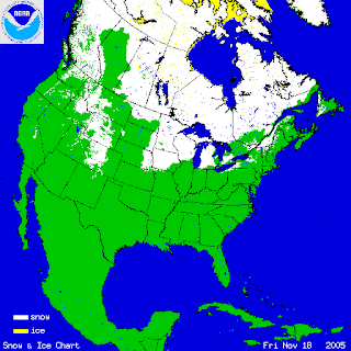
Another factor to consider right now is the amount of snowpack in North America. Here are the snowpack maps from 2001-2009 in mid-November:

Notice this year's map looks similar to 2001, 2004, 2006, and 2007, which resulted in roughly warmer-than-average Winters in Central Virginia. What is more significant, perhaps, is how similar 2009 and 2001 are to each other in snow-coverage. The Winter of 2001-2002 was the 7th warmest on record.
Any cold fronts we receive in the coming weeks will not be moving over a large southward snow-covered surface to our northwest, which means they loose some of their "punch" and are unable to advect as cold of air to Central Virginia.
--Blog entry by Chief Meteorologist Zach Daniel, and Meteorologists Aaron Justus and Carrie Rose.


Maybe all that ice and snow is having an effect on our weather this afternoon. This is the forecast I just obtained from Weather Underground: Cloudy with a 50 percent chance of rain showers. Highs in the upper 60s. Temperature falling to around 49 below. Southeast winds 5 to 10 mph. Wind chill values as low as 120 below.
ReplyDelete